


Contact(s)
- Learn how to read these charts on our River and stream flows page.
- This river data can be downloaded from our Data Downloads page.
Lake Erie Data
The above chart displays data collected from Ministry of Natural Resources and Forestry (MNRF) and GRCA gauges that monitor Lake Erie. Data on the chart is updated every 10 minutes. The chart also identifies five Lake Erie Flood Warning Zones which affect properties in Haldimand County. Flood threshold elevations for the warning zones are: Zone 1 – 175.5m, Zone 2 - 175.75m, Zone 3 – 176.0m, Zone 4 – 176.25m, Zone 5 – 176.5m.
If you are a Haldimand County resident or business and want to find out if your property is affected, visit www.haldimandcounty.ca/floods to map your property and learn more about who you should contact in the event of Lake Erie flooding.
Lake Erie Forecast
Also included on the Lake Erie chart above is a provisional lake surge model forecast provided courtesy of the MNRF. This forecast is updated twice daily at 1:00 a.m. and 1:00 p.m. and provides a 48-hour forecast outlook of potential lake surge events.
Lake Erie Levels
Lake Erie levels are naturally impacted by many factors including wind, precipitation, and ice cover. Normal fluctuations in lake levels can happen both seasonally and longer-term. Unlike the lower St. Lawrence and Lake Ontario, Lake Erie is unregulated and human influences on water levels are negligible.
Lake Erie static levels typically peak in May/June each year due to spring runoff which causes the level of theGreat Lakes to rise.
Weather systems can cause water to surge on Lake Erie resulting in water levels increasing above the normal (static) level. There is a higher risk of seasonal lake surge events between November and April. Waves associated with these surge events can further increase water levels.
More Information
- Port Colborne gauge – Department of Fisheries and Oceans (Lake Erie voice announcing system 905-835-2501)
- Port Dover gauge – Department of Fisheries and Oceans (Lake Erie voice announcing system 519-583-2259)
- Great Lakes Water Levels and Related Data – Environment Canada
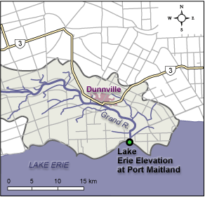
Location of Lake Erie Guage