Connect
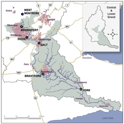
Location of flow gauges in the Central Lower Grand River area


Contact(s)
- Learn how to read these charts on our River and stream flows page.
- This river data can be downloaded from our Data Downloads page.
Critical flows
| Gauge (Community) | Flow (m3/s) | Significance |
|---|---|---|
| West Montrose | 5 | Normal summer low flow |
| 125 | Campground floods | |
| 280 | Village floods | |
| 670 | 1974 flood | |
| Bridgeport | 11 | Normal summer low flow |
| 265 | Water at banks; low-lying areas flooded | |
| 1,300 | 1974 flood | |
| 1,700 | Dike capacity | |
| Victoria St (Kitchener) | 265 | Water at banks; low-lying areas flooded |
| Beaverdale (Cambridge) | See Speed & Eramosa River chart | |
| St. Jacobs | See Conestogo River chart | |
| Doon (Kitchener) | 11 | Normal summer low flow |
| 320 | Water at banks; low-lying areas flooded | |
| 1,420 | 1974 flood | |
| Galt (Cambridge) | 15 | Normal summer low flow |
| 400 | Water at banks; low-lying areas flooded | |
| 638 | Water St. closed south of Ainslie | |
| 1,050 | Concession St. bridge closed | |
| 1,472 | Main St. bridge closed | |
| 1,550 | 1974 flood | |
| 1,628 | Parkhill St. bridge closed | |
| 2,352 | Dike capacity | |
| Brantford (Brantford) | 20 | Normal summer low flow |
| 400 | Water at banks; low-lying areas flooded | |
| 600 | Gilkison St. closed | |
| 1,800 | 1974 flood | |
| 3,400 | Dike capacity | |
| Brantford (Caledonia) | 400 | Water at banks; low-lying areas flooded |
| 1,040 | Caledonia Arena floods | |
| 1,800 | 1974 flood | |
| Brantford (Six Nations) | 555 | Fourth Line floods |
| York (York) | 22 | Normal summer low flow |
| 300 | Water at banks; low-lying areas flooded | |
| York (Cayuga) | 300 | Water at banks; low-lying areas flooded |
| 300 | Campground flooding on Lower Grand | |
| 600 | Grand Sports Road floods | |
| 1,800 | 1974 flood |
Location of flow gauges in the Central Lower Grand River area
Provisional Data